How To Create a Territory Using Shapefile From MappyField 365 and Azure Maps in Dynamics 365?
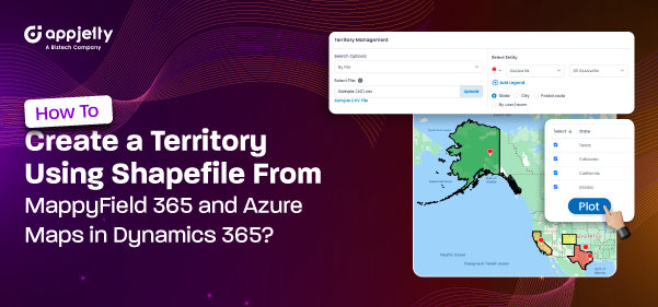
Managing activities based on regions or areas can be challenging for managers using Dynamics CRM alone. However, it is important to have an overview of sales, marketing, or services based on different regions and areas. Microsoft Dynamics 365 provides Sales Territory Management within CRM. You can manage specific areas for activities such as Sales, Services, Marketing Campaigns, Sales Demos, etc., from the Dynamics CRM Map. With AppJetty MappyField 365, you can plot your CRM data geographically. Users can get detailed information about their CRM activities based on the prospect’s location on the MappyField 365 map. MappyField 365 allows you to manage territories in four ways: By Region, Drawing, Territory, and File. If you have a shapefile of specific areas, you can import the shapefile to create a Territory on the MappyField 365 map and perform activities within that shape/region. This is one of the prominent ways for Dynamics 365 CRM users to plot records or locations on the map, ove...